|
|
 GLACIORISK EUROPEAN PROJECT
|
|
France (CEMAGREF,
ETNA,
ONF-RTM,
LGGE-CNRS), Italy (CNR-IRPI,
SMS/Nimbus), Norway (UOSLO,
NVE),
Iceland (UI
(IS)), Austria (DGGS),
Switzerland (VAW-ETHZ) |
|
WELCOME TO GRIDABASE, GLACIER RISKS DATA BASE :
MAIN MENU
Gridabase
was implemented by
SMS/Nimbus
|
|
|
|
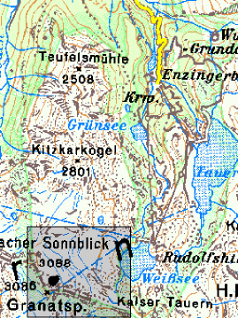
GLACIER "SONNBLICKKEES"
Risk type: glacier flood (contain both lakes and water pocket)
Glacier list |
Statistics
|
| Type: |
Cirque glacier |
| Country: |
Austria |
| Region: |
Salzburg |
| Massif/Ice Cap: |
Granatspitz mountains |
| Municipality: |
Uttendorf |
| Municipality code: |
|
| Location: |
The glacier is situated east of Stubacher Sonnblick (3088 m) and Granatspitze (3086 m) close to the alpine center "Rudolphshütte". |
|
|
| Latitude (°, cent): |
47.13 N |
|
| Longitude (°, cent): |
12.6 E |
| Surface (km2): |
1.7 |
| Lenght (km): |
1.5 |
| Width (km): |
1.5 |
| Min. altitude (m): |
2500 |
| Max. altitude (m): |
3030 |
| Orientation (°) |
50 |
| Slope (°) |
20 |
|
|
EVENT: Date
19/10/2001
- Date quality: |
 |
| Type: |
Ice avalanches |
 |
|
| Description |
In the night from 18th to 19th of October 2001 an iceavalanche came down over a rockwall in the middle of the glacier. The avalanche started at 2650 m altitude and reached down to 2540 m. It developed a deposit area of 130 * 70 m and had a volume of 15.000 m³. Fortunately the last years snow that still covered the glacier surface had the effect of brake. Therefore the iceavalanche stopped before it could reach a proglacial lake. |
|
Effects: |
loss of an interesting ice climbing training area |
| Deaths(#) |
0 |
|
|
|
Injuried (#) |
0 |
| Note |
|
|
DAMAGES |
|
|
|
BIBLIOGRAPHY |
|
|
Slupetzky, H.,, 2001 - Eissturz. Fürlegg-Eisbruch in Bewegung Berg & Steigen 4/01, S.14-15. |
|
|