|
|
|
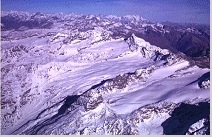
GLACIER "GLACIER DU MULINET"
Risk type: ice avalanches
Glacier list |
Statistics
|
| Type: |
Cirque glacier |
| Country: |
France |
| Region: |
Savoie |
| Massif/Ice Cap: |
Vanoise |
| Municipality: |
|
| Municipality code: |
|
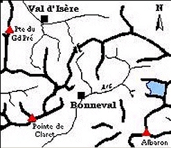
| Location: |
Glacier situated under the Roc of the Mulinet and the Pointe of Grand Méan.
It looks directly on the small valley of the Mulinet. |
|
|
| Latitude (°, cent): |
45,5 |
|
| Longitude (°, cent): |
7 |
| Surface (km2): |
4 |
| Lenght (km): |
2,5 |
| Width (km): |
|
| Min. altitude (m): |
2300 |
| Max. altitude (m): |
3400 |
| Orientation (°) |
315 |
| Slope (°) |
24 |
|
|
EVENT: Date
//
- Date quality: |
 |
| Type: |
Ice avalanches |
 |
|
| Description |
at this time, the glacier arrives above the glacier of the Sources of the Arc, and a lot of serac falls happens, making a suture between the two glaciers (Sources of the Arc and Mulinet). |
|
Effects: |
no damages |
| Deaths(#) |
0 |
|
|
|
Injuried (#) |
0 |
| Note |
this glacier is limited on its downstream end by a rock bar. It ends making a vertical front from where many seracs take off. These ice falls can make regenerated glaciers (or neve). The moraine of the glacier of Mulinet usually generates mud-flows (p55 « les risques naturels d’origine glaciaire ») |
|
DAMAGES |
|
|
|
BIBLIOGRAPHY |
|
|
Mougin, P., 1924 - Avalanches, débâcles et érosions glaciaires. Etudes glaciologiques, tome V, Imprimerie nationale. Paris, p. 161 |
|
|