|
|
 GLACIORISK EUROPEAN PROJECT
|
|
France (CEMAGREF,
ETNA,
ONF-RTM,
LGGE-CNRS), Italy (CNR-IRPI,
SMS/Nimbus), Norway (UOSLO,
NVE),
Iceland (UI
(IS)), Austria (DGGS),
Switzerland (VAW-ETHZ) |
|
WELCOME TO GRIDABASE, GLACIER RISKS DATA BASE :
MAIN MENU
Gridabase
was implemented by
SMS/Nimbus
|
|
|
|
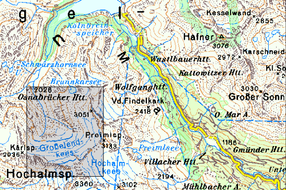
GLACIER "GROßELENDKEES"
Risk type: ice avalanches
Glacier list |
Statistics
|
| Type: |
Cirque glacier |
| Country: |
Austria |
| Region: |
Carinthia |
| Massif/Ice Cap: |
Ankogel mountains |
| Municipality: |
Malta |
| Municipality code: |
|
| Location: |
The glacier is situated at the north face of Hochalmspitze (3360 m) which is the highest summit of the Ankogel mountains. |
|
|
| Latitude (°, cent): |
47.03 N |
|
| Longitude (°, cent): |
13.3 E |
| Surface (km2): |
2.8 |
| Lenght (km): |
1.4 |
| Width (km): |
2.2 |
| Min. altitude (m): |
2380 |
| Max. altitude (m): |
3160 |
| Orientation (°) |
340 |
| Slope (°) |
26.1 |
|
|
EVENT: Date
14/3/1937
- Date quality: |
 |
| Type: |
Ice avalanches |
 |
|
| Description |
In March 1937 a quite small ice avalanche broke down from the upper part of the glacier followed by a much larger snow avalanche which dragged away the whole snow cover from the glacier surface. The avalanche came down about 1000 m of altitude and spread over 5 kilometers. The ground of the valley was filled up with 30 meters of snow. Some small agricultural huts and several acres of pasture land were destroyed |
|
Effects: |
Agricultural damages and loss of pasture land for two years. |
| Deaths(#) |
0 |
|
|
|
Injuried (#) |
0 |
| Note |
|
|
DAMAGES |
|
| Type: |
|
Description: |
|
|
BIBLIOGRAPHY |
|
|
FRESACHER, W, 1967 - Fels- und Gletscherabbrüche im Maltatal Die Kärntner Landsmannschaft. Heft 2/1967, S.10-11. |
|
KORDON, F, 1938 - Ungewöhnlicher Lawinenabgang im Großelend (Kärnten, Ankogelgruppe). Carinthia II. 128.Jg. (48.Jg.d.Carinthia II), S.23-25 |
|
|