|
|
 GLACIORISK EUROPEAN PROJECT
|
|
France (CEMAGREF,
ETNA,
ONF-RTM,
LGGE-CNRS), Italy (CNR-IRPI,
SMS/Nimbus), Norway (UOSLO,
NVE),
Iceland (UI
(IS)), Austria (DGGS),
Switzerland (VAW-ETHZ) |
|
WELCOME TO GRIDABASE, GLACIER RISKS DATA BASE :
MAIN MENU
Gridabase
was implemented by
SMS/Nimbus
|
|
|
|
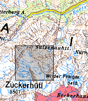
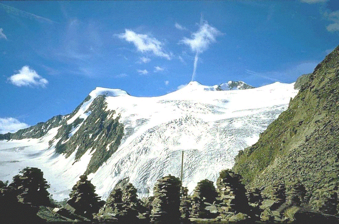
GLACIER "SULZENAUFERNER"
Risk type: glacier flood (contain both lakes and water pocket)
Glacier list |
Statistics
|
| Type: |
Valley glacier |
| Country: |
Austria |
| Region: |
Tyrol |
| Massif/Ice Cap: |
Stubaier Alps |
| Municipality: |
Neustift/Stubaivalley |
| Municipality code: |
|
| Location: |
The glacier is situated north of Zuckerhütl (3507 m) in the Ruetzvalley in the Stubaier alpes. |
|
|
| Latitude (°, cent): |
46,98 N |
|
| Longitude (°, cent): |
11,15 E |
| Surface (km2): |
4,7 |
| Lenght (km): |
3,7 |
| Width (km): |
1,8 |
| Min. altitude (m): |
2480 |
| Max. altitude (m): |
3500 |
| Orientation (°) |
20 |
| Slope (°) |
17 |
|
|
EVENT: Date
//
- Date quality: |
 |
| Type: |
|
 |
|
| Description |
At the right side of the glacier tongue there was situated a lake (Blaue Lacke) in the little iceage. In the year 1770 a huge piece of ice fell into the lake and the water flooded down the Sulzbach-river and the Ruzbach-river and caused serious damages in the valley. |
|
Effects: |
unknown, probably at least agricultural damages |
| Deaths(#) |
0 |
|
|
|
Injuried (#) |
0 |
| Note |
|
|
DAMAGES |
|
|
|
BIBLIOGRAPHY |
|
|
KINZL, H, 1949 - Formenkundliche Beobachtungen im Vorfeld der Alpengletscher Veröffentlichungen des Museum Ferdinandeum in Innsbruck. Bd. 26, Jg.1946, S.61-82 |
|
unknown, 1825 - Das Thal Stubei und dessen Bewohner Zeitschrift des Ferdinandeums für Tirol und Vorarlberg, I.-II.Bd., S.166-246. |
|
|