|
|
 GLACIORISK EUROPEAN PROJECT
|
|
France (CEMAGREF,
ETNA,
ONF-RTM,
LGGE-CNRS), Italy (CNR-IRPI,
SMS/Nimbus), Norway (UOSLO,
NVE),
Iceland (UI
(IS)), Austria (DGGS),
Switzerland (VAW-ETHZ) |
|
WELCOME TO GRIDABASE, GLACIER RISKS DATA BASE :
MAIN MENU
Gridabase
was implemented by
SMS/Nimbus
|
|
|
|
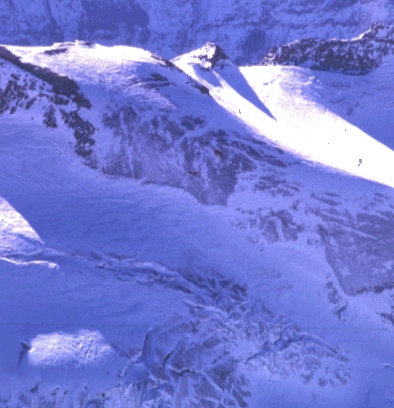
GLACIER "VALLONNET SUPÉRIEUR"
Risk type: ice avalanches
Glacier list |
Statistics
|
| Type: |
|
| Country: |
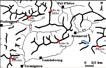
France |
| Region: |
Savoie |
| Massif/Ice Cap: |
Vanoise |
| Municipality: |
|
| Municipality code: |
|
| Location: |
Glacier in scarf/sling, localised under the Albaron and the tips of Grand Fond, which overhang on the "Inférieur of Vallonnet" glacier. |
|
|
| Latitude (°, cent): |
45.2 N |
|
| Longitude (°, cent): |
7.05 E |
| Surface (km2): |
1.7 |
| Lenght (km): |
2.5 |
| Width (km): |
|
| Min. altitude (m): |
2700 |
| Max. altitude (m): |
3600 |
| Orientation (°) |
|
| Slope (°) |
20 |
|
|
EVENT: Date
//
- Date quality: |
 |
| Type: |
Ice avalanches |
 |
|
| Description |
On several occasions before 1905 : serac detached from the « glacier supérieur » feed regularly the glacier "Inférieur du Vallonet" (regenerated) |
|
Effects: |
no damages |
| Deaths(#) |
0 |
|
|
|
Injuried (#) |
0 |
| Note |
the quality of the information is bad, only the repeated events are mentioned, without any dates, neither any concurrency frequency |
|
DAMAGES |
|
|
|
BIBLIOGRAPHY |
|
|
Mougin, P., 1925 - Avalanches, débâcles et érosions glaciaires Etudes glaciologiques, tome V, Imprimerie nationale. Paris, p. 161. |
|
|