|
|
 GLACIORISK EUROPEAN PROJECT
|
|
France (CEMAGREF,
ETNA,
ONF-RTM,
LGGE-CNRS), Italy (CNR-IRPI,
SMS/Nimbus), Norway (UOSLO,
NVE),
Iceland (UI
(IS)), Austria (DGGS),
Switzerland (VAW-ETHZ) |
|
WELCOME TO GRIDABASE, GLACIER RISKS DATA BASE :
MAIN MENU
Gridabase
was implemented by
SMS/Nimbus
|
|
|
|
GLACIER "PATINOIRE"
Risk type: miscellaneous
Glacier list |
Statistics
|
| Type: |
Cirque glacier |
| Country: |
France |
| Region: |
Savoie |
| Massif/Ice Cap: |
Vanoise |
| Municipality: |
|
| Municipality code: |
|
| Location: |
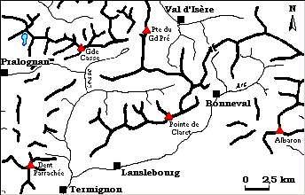
on the south slope of the « pointe of Vallonet (3372m) » upstream from Pralognan. |
|
|
| Latitude (°, cent): |
45,24 |
|
| Longitude (°, cent): |
6,45 |
| Surface (km2): |
0,5 |
| Lenght (km): |
0,9 |
| Width (km): |
|
| Min. altitude (m): |
2512 |
| Max. altitude (m): |
3260 |
| Orientation (°) |
|
| Slope (°) |
38 |
|
|
EVENT: Date
27/7/1964
- Date quality: |
 |
| Type: |
Glacier flood (contain both lakes and water pocket) |
|
|
| Description |
the glacier melting has increased during the last warmth period. The glacier of the Patinoire would has been fallen in the lake and the wave has broken the dam. The mass of water released, has followed the brook of Vallonet, a affluent of Glière’s brook. The flow has increased because of the bank’s erosion and has led a rise in the “Doron de Pralognan” water level |
|
Effects: |
the EDF’s intake of water has been damaged, the main street of Pralognan has been flooded, bridges have been taken away and breached in the road; all these damages have compromised the tourist season. |
| Deaths(#) |
0 |
|
|
|
Injuried (#) |
0 |
| Note |
the quality of the information is medium; we only know consequences. We don’t know neither the volume of the lake, nor the phenomenon which has caused the bursting of the lake too |
|
DAMAGES |
|
|
|
BIBLIOGRAPHY |
|
|
RTM de Chambéry, 0 - Archives du RTM de Chambéry |
|
|