|
|
 GLACIORISK EUROPEAN PROJECT
|
|
France (CEMAGREF,
ETNA,
ONF-RTM,
LGGE-CNRS), Italy (CNR-IRPI,
SMS/Nimbus), Norway (UOSLO,
NVE),
Iceland (UI
(IS)), Austria (DGGS),
Switzerland (VAW-ETHZ) |
|
WELCOME TO GRIDABASE, GLACIER RISKS DATA BASE :
MAIN MENU
Gridabase
was implemented by
SMS/Nimbus
|
|
|
| Type: |
Valley glacier |
| Country: |
France |
| Region: |
|
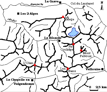
| Massif/Ice Cap: |
Ecrins |
| Municipality: |
|
| Municipality code: |
|
| Location: |
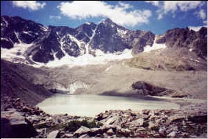
This Glacier is localised under the mountain of the Agneaux, the « Pic du Glacier d'Arsine » and the « Pic de Neige Cordier », overlooking the valley of "Petit Tabuc", under the hamlet of "Casset" |
|
|
| Latitude (°, cent): |
44,57 N |
|
| Longitude (°, cent): |
6,24 E |
| Surface (km2): |
2,6 |
| Lenght (km): |
1,7 |
| Width (km): |
|
| Min. altitude (m): |
2450 |
| Max. altitude (m): |
3600 |
| Orientation (°) |
|
| Slope (°) |
9 |
|
|
EVENT: Date
1/1/1986
- Date quality: |
 |
| Type: |
Glacier flood (contain both lakes and water pocket) |
 |
 |
| Description |
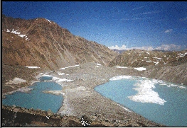
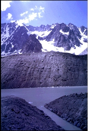
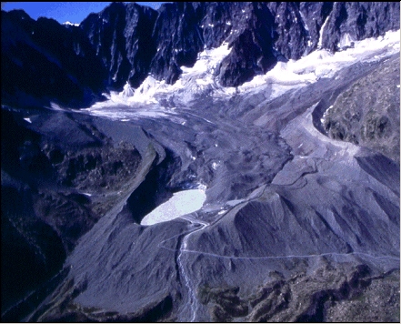
Since 1952, a small lake localised at the snout of Arsine glacier is visible on aerial photography (I.G.N.); but in July 1985 M. Vallon (L.G.G.E.) has noticed an important evolution of the lake. Actually, looking its evolution between 1952 and 1985, he has noticed that its surface has increased glacier from 0.7 ha (in 1952) to 3.3 ha (in 1969) and 5,9 ha (in 1985) (cf. chart 1-1 underneath), and he has given the alert. The lake contains at that time approximately 800.000 m3 water, and its level increases continually (50 cm/year on average), an overflowing seems to be ineluctable (le franc-bord it is only of 2 m in 1985 !) and threaten to flood the small valley of "Petit Tabuc" and downstream, the hamlet of Casset. Some works have been decided in order to control the evolution of the lake. The best proposition seems to be : the creation of a permanent flowing channel of 250m long, permitting the evacuation of a 15 m3/s flow and so the maintain of the lake level at an defined cote . It seems to be more interesting at middle term. But works have started in the urgency in April, 14th, 1986, at this season, the lake and its surroundings are recovered with snow : it has needed more than 15 days of efforts for climbing the engines so far as the Col d’Arsine (2348 m). Only after two months of works in hard conditions the channel is put in device, in June, 23rd, 1986, brushing aside the risk of an uncontrolled overflowing. The global cost of these works is 12,5 MF (1986). |
|
Effects: |
Potentials consequences : discharging of the lake in the torrent of « Petit Tabuc », leading a flood, and a mud-flow, touching the hamlet of « Casset" (free town of Monêtier-les-Bains) and the Guisane valley |
| Deaths(#) |
0 |
|
|
|
Injuried (#) |
0 |
| Note |
the quality of the information in relation with this event excellent, because of the studies and works realised |
|
DAMAGES |
|
|
|
BIBLIOGRAPHY |
|
|
Lahousse, P., et Guen, R., 1998 - Le lac pro glaciaire d’Arsine, un risque de vidange brutale définitivement écarté ? Revue de Géographie Alpine, LXXXVI (3), p. 49-59. |
|
R.T.M. de Gap, 0 - archives du R.T.M. de Gap |
|
Vallon, M., 1989 - Evolution, water balance, potential hazards, and control of a pro glacial lake in the French alps Annals of Glaciology, 13, p. 273-278. |
|
Van Effenterre, C., 1987 - Lac du glacier d’Arsine, Etude de risque et travaux de protection Neige et Avalanche, revue de l’ANENA, 43, p. 35-44. |
|
Vivian, R., 1967 - Fiches des glacier français : le glacier d’Arsine Revue de Géographie Alpine, LV (2), p. 397-402. |
|
|