|
|
 GLACIORISK EUROPEAN PROJECT
|
|
France (CEMAGREF,
ETNA,
ONF-RTM,
LGGE-CNRS), Italy (CNR-IRPI,
SMS/Nimbus), Norway (UOSLO,
NVE),
Iceland (UI
(IS)), Austria (DGGS),
Switzerland (VAW-ETHZ) |
|
WELCOME TO GRIDABASE, GLACIER RISKS DATA BASE :
MAIN MENU
Gridabase
was implemented by
SMS/Nimbus
|
|
|
|
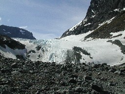
GLACIER "STORGJUVBREEN"
Risk type: miscellaneous
Glacier list |
Statistics
|
| Type: |
Valley glacier |
| Country: |
Norway |
| Region: |
Oppland |
| Massif/Ice Cap: |
|
| Municipality: |
Lom |
| Municipality code: |
|
| Location: |
In Jotunheimen, north of Norways highest mountain peak, Galdhopiggen (2469 m asl.) |
|
|
| Latitude (°, cent): |
61,645 N |
|
| Longitude (°, cent): |
8,281 E |
| Surface (km2): |
4,48 |
| Lenght (km): |
4,3 |
| Width (km): |
|
| Min. altitude (m): |
1380 |
| Max. altitude (m): |
2240 |
| Orientation (°) |
360 |
| Slope (°) |
|
|
|
EVENT: Date
1/7/2001
- Date quality:months |
 |
| Type: |
Accident mountaineering |
|
|
| Description |
rockfall while two persons were walking beneath the moraineridge |
|
Effects: |
|
| Deaths(#) |
|
|
|
|
Injuried (#) |
2 |
| Note |
F 30, M 35. participating in "71 grader nord" |
|
DAMAGES |
|
|
|
BIBLIOGRAPHY |
|
|
|