|
|
 GLACIORISK EUROPEAN PROJECT
|
|
France (CEMAGREF,
ETNA,
ONF-RTM,
LGGE-CNRS), Italy (CNR-IRPI,
SMS/Nimbus), Norway (UOSLO,
NVE),
Iceland (UI
(IS)), Austria (DGGS),
Switzerland (VAW-ETHZ) |
|
WELCOME TO GRIDABASE, GLACIER RISKS DATA BASE :
MAIN MENU
Gridabase
was implemented by
SMS/Nimbus
|
|
|
|
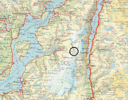
GLACIER "FOLGEFONNI, SØNDRE (N)"
Risk type: glacier flood (contain both lakes and water pocket)
Glacier list |
Statistics
|
| Type: |
Outlet glacier |
| Country: |
Norway |
| Region: |
Hordaland |
| Massif/Ice Cap: |
Søndre Folgefonni |
| Municipality: |
Kvinnherad |
| Municipality code: |
|
| Location: |
East of Hardangerfjorden and west of Sørfjorden |
|
|
| Latitude (°, cent): |
60,104 N |
|
| Longitude (°, cent): |
6,444 E |
| Surface (km2): |
1,55 |
| Lenght (km): |
3,7 |
| Width (km): |
|
| Min. altitude (m): |
1160 |
| Max. altitude (m): |
1560 |
| Orientation (°) |
360 |
| Slope (°) |
|
|
|
EVENT: Date
7/9/1966
- Date quality:days |
 |
| Type: |
Glacier flood (contain both lakes and water pocket) |
|
|
| Description |
All glacier streams from Folgefonna, HO. Floods. Remnant of a tropical cyclone |
|
Effects: |
Extreme glacier melting |
| Deaths(#) |
|
|
|
|
Injuried (#) |
|
| Note |
|
|
DAMAGES |
|
|
|
BIBLIOGRAPHY |
|
|
|