|
|
 GLACIORISK EUROPEAN PROJECT
|
|
France (CEMAGREF,
ETNA,
ONF-RTM,
LGGE-CNRS), Italy (CNR-IRPI,
SMS/Nimbus), Norway (UOSLO,
NVE),
Iceland (UI
(IS)), Austria (DGGS),
Switzerland (VAW-ETHZ) |
|
WELCOME TO GRIDABASE, GLACIER RISKS DATA BASE :
MAIN MENU
Gridabase
was implemented by
SMS/Nimbus
|
|
|
|
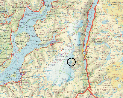
GLACIER "BUERBREEN"
Risk type: glacier flood (contain both lakes and water pocket)
Glacier list |
Statistics
|
| Type: |
Outlet glacier |
| Country: |
Norway |
| Region: |
Hordaland |
| Massif/Ice Cap: |
Folgefonna |
| Municipality: |
Odda |
| Municipality code: |
|
| Location: |
East of Handangerfjorden and west of the mountain plateau Hardangervidda |
|
|
| Latitude (°, cent): |
60,032 N |
|
| Longitude (°, cent): |
6,432 E |
| Surface (km2): |
15,48 |
| Lenght (km): |
7,5 |
| Width (km): |
|
| Min. altitude (m): |
620 |
| Max. altitude (m): |
1640 |
| Orientation (°) |
45 |
| Slope (°) |
|
|
|
EVENT: Date
1/8/2002
- Date quality:months |
 |
| Type: |
Glacier flood (contain both lakes and water pocket) |
|
|
| Description |
Small lake (1200 m asl) 2 km south of Buerbreen, draining to Buervatn and Sandvinvatnet in Odda. Volume: 1 mill m3. |
|
Effects: |
|
| Deaths(#) |
|
|
|
|
Injuried (#) |
|
| Note |
Ref: HAE, 2002 |
|
DAMAGES |
|
|
|
BIBLIOGRAPHY |
|
|
|