|
|
 GLACIORISK EUROPEAN PROJECT
|
|
France (CEMAGREF,
ETNA,
ONF-RTM,
LGGE-CNRS), Italy (CNR-IRPI,
SMS/Nimbus), Norway (UOSLO,
NVE),
Iceland (UI
(IS)), Austria (DGGS),
Switzerland (VAW-ETHZ) |
|
WELCOME TO GRIDABASE, GLACIER RISKS DATA BASE :
MAIN MENU
Gridabase
was implemented by
SMS/Nimbus
|
|
|
|
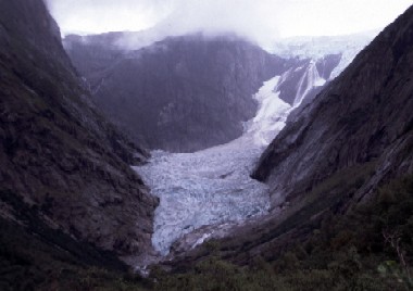
GLACIER "BRENNDALSBREEN"
Risk type: glacier length changes
Glacier list |
Statistics
|
| Type: |
Outlet glacier |
| Country: |
Norway |
| Region: |
Sogn og Fjordane |
| Massif/Ice Cap: |
Jostedalsbreen |
| Municipality: |
Stryn |
| Municipality code: |
|
| Location: |
|
|
|
| Latitude (°, cent): |
61,577 N |
|
| Longitude (°, cent): |
6,908 E |
| Surface (km2): |
1,44 |
| Lenght (km): |
1 |
| Width (km): |
|
| Min. altitude (m): |
1440 |
| Max. altitude (m): |
1660 |
| Orientation (°) |
270 |
| Slope (°) |
|
|
|
EVENT: Date
1/12/1743
- Date quality:months |
 |
| Type: |
Glacier length changes |
|
|
| Description |
Brenndalsbreen advanced to the main valley (Briksdalen). Avalanche from the glacier terminus.
|
|
Effects: |
The farm Tungøyane in Briksdalen, Olden, was destroyed. Only two people survived. |
| Deaths(#) |
3 |
|
|
|
Injuried (#) |
|
| Note |
Correct date 1743!!
Number of dead not known, 3 taken as a minimum. |
|
DAMAGES |
|
|
|
BIBLIOGRAPHY |
|
|
|