|
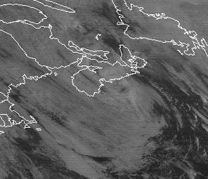
This zoomed-in visible image of an unnamed hurricane was taken at 1801 UTC November 1, 1991 when the storm was at its peak intensity (980 mb with sustained winds of 65 knots). The hurricane is embedded in the center of a much larger circulation that is the remains of the dying Halloween Storm of 1991. This storm, called the " perfect storm" by the National Weather Service, became a topic in Sebastian Junger's best-selling 1997 novel "The Perfect Storm."
Event Discussion
Unnamed Hurricane of 1991Conditions at the Time of the Image An unnamed hurricane at the center of the dying Halloween Storm of October, 1991 has reached its peak intensity in this visible GOES 7 image from 1801 UTC on November 1, 1991. The storm was packing sustained winds of 65 knots and the minimum central pressure was 980 millibars. The counterclockwise swirl of the larger cyclone is still very evident in this view of the northwest Atlantic and Eastern U.S. The storm was moving rapidly northeastward and hit Nova Scotia as a weakened tropical storm the next day. It was the eighth hurricane (and 34th tropical cyclone of either tropical storm or hurricane intensity) which remained unnamed since the official naming of Atlantic tropical cyclones began in 1950.
History of the Storm A large and very powerful extratropical cyclone pounded the Western
Atlantic in the closing days of October 1991. This storm was so severe
that it became known as the Halloween Storm and was called a "perfect
storm" by the National Weather Service. One of it's many casualties was
the swordfishing boat the Andrea Gail, which sank with all hands on
board and became the basis for Sebastain Junger's novel "The Perfect
Storm." The Halloween Storm had weakened and drifted southward to near 36.7 N, 71.5 W by 18:00 UTC on October 31. (See Figure 1). At that time, the central pressure had risen to 996 mb and winds had decreased to 40 knots. With the low centered over warm waters of the Gulfstream, subtropical characteristics were acquired. By this time, there was no longer a well-defined baroclinic zone across the area (i.e., temperatures were nearly uniform in all directions), but the center was not yet under the central dense overcast feature of tropical low pressure centers.
By 0600 UTC on November 1, the storm was in the process of making a
counter-clockwise loop and central convection had increased to the point
where a tropical cyclone (of tropical storm intensity) could be
identified at the center (See Figure 2). By nine hours later, at 1400
UTC, an eye was forming and the storm was near hurricane intensity.
Maximum intensity of the storm was reached at 1800 UTC (See Main Gallery
image above) when a minimum central pressure of 980 millibars with
sustained winds of 65 knots was reached. An Air Force Reserve Unit
aircraft investigated the hurricane around 0000 UTC on November 2 and
found maximum flight level (850 mb) winds of 86 knots, a 4 degree C rise
in air temperature at the center, and an estimated sea level pressure of
981 millibars. The radius of maximum winds was about 30 nautical miles.
(In contrast, and typical of older massive extratropical storms, the
Halloween storm had a more uniform area of gale force winds extending
well over 300 n mi from its center with no clearly defined wind radius.)
With the warm core finding and other data, this flight confirmed that
the center of the Halloween Storm was now a hurricane! Though the formation of a hurricane in the center of a large
extratropical low is unusual, it has happened several times before.
Hurricane Karl formed in the center of a deep layer non-tropical cyclone
in the central Atlantic on November 25, 1980 and was of hurricane
strength until November 27, 1980. By their very nature, the centers of
deep layer cyclones are areas of small temperature gradients and light
vertical wind shear. Given sufficient heating from the sea surface
below, tropical cyclone formation within the larger low pressure center
is possible.
After its formation, the unnamed hurricane began speeding to the
northeast. It passed over the same area where the extratropical cyclone
had passed two days earlier (before the formation of the hurricane). By
0600 UTC November 2, six hours after the reconnaissance flight, the
storm had weakened to tropical storm status and central pressure had
risen to 988 millibars. Even so, the SFL Atlas, A Bahamian ship 110
miles southwest of the center, reported winds of 45 knots. Accelerating
to the northeast, the storm made landfall near Halifax, Nova Scotia as a
tropical storm around 1400 UTC (See Figures 4 and 5). The lowest
reported pressure on land was 998.1 millibars at Shearwater, near
Halifax, and the Canadian Coast Guard station at Chebucto Head (8 miles
south of Shearwater) reported sustained winds of 40 knots with gusts to
45 knots. Radar showed curved rain bands on the western side of the
system, which weakened as they approached the coast. Bedford reported
only 0.27 inches and Shearwater a mere 0.23. No damage was reported from
the unnamed tropical cyclone and it dissipated 10 hours after landfall.
Why Was the Hurricane Unnamed? The National Hurricane Center (now called the Center for Tropical
Prediction) began naming tropical storms and hurricanes in 1950. The
hurricane which developed at the center of the dying Halloween
Storm met all meteorological criteria to be designated as a
hurricane, and a track for it is shown on the National Hurricane
Center's 1991 "North Atlantic Hurricane Tracking Chart." So why did the
storm remain unnamed? At the time of the hurricane, news media attention was still focused
on the massive damage from Maine to Florida caused by the slowly dying
Halloween (or "Perfect") Storm. It was felt that naming the hurricane
would cause major confusion on the part of the media, Emergency
Management officials, and the public. Since the hurricane was expected
to be short-lived and primarily of concern to maritime interests, it was
decided to leave the storm unnamed. All associated warnings were handled
through enhanced High Seas and Offshore and Coastal Waters Forecasts.
The decision was made jointly by NOAA's National Meteorological Center,
selected National Weather Service Forecast Offices, the U.S. Navy, and
the Maritimes Weather Center of the Atmospheric Environment Service of
Canada. The unnamed hurricane brought a bizarre ending to one of the
most massive Atlantic storms of record.
Typical Hurricane Endings Extensive extratropical cyclones such as the Halloween Storm usually
cover larger areas than even the largest hurricanes or typhoons.
Sometimes, as was the case with Hurricane Grace's interaction with the
Halloween Storm, a hurricane will be absorbed by a larger extratropical
storm and the hurricane's energy becomes a part of the larger storm's
circulation. This sometimes leads to a dramatic energizing of the larger
storm, often with disastrous consequences. Such was the case with
Hurricane Hazel in October, 1954 which first struck the Carolinas as a
Category 4 hurricane, and then merged with a low pressure center to
become a monstrous extratropical storm which devastated Toronto, Canada
causing 76 deaths. A cold front associated with the Halloween Storm
overtook Grace at 1800 UTC on the 29th and the low pressure center
absorbed the remnants of the hurricane. Similar absorption of hurricanes
by extratropical storms is a common occurrence, and such is the end of
many tropical cyclones. Still other tropical cyclones wander over land
or over cooler ocean waters and slowly fade away or loose their tropical
characteristics. Unusual Endings to Extratropical Storms Though hurricanes are often absorbed by major extratropical storms, a reverse process can occur, i.e., under the right conditions, a weak extratropical cyclone can remain over warm ocean water long enough that the storm becomes "warm core" and evolves into a tropical storm, and later possibly a hurricane. If this occurs, it is often in the early part of the hurricane season. A favored place is off the Carolina or Georgia coastlines in July or early August when weak low pressure centers sometimes stall offshore and later become tropical storms or hurricanes. The process can occur at any time, however. Hurricane Grace, which was absorbed by the Halloween Storm, had similar origins in that it was initially subtropical in character and formed primarily from a mid-level low pressure center which extended down to the warm ocean surface. An even rarer event is the conversion of the center region of a major
extratropical storm into one with tropical characteristics. As with most
major storms, the Halloween Storm underwent a complete occlusion process
by which surface frontal boundaries underneath the spinning vortex
center disappear. The central portion of such a deep-layer cyclone at
this time is relatively slow moving; the surface air temperature is
relatively uniform with small temperature gradients; and there is light
vertical wind shear. If the center of the low is sitting over a very
warm ocean water, the air in the center of the low can eventually become
warm core at all levels and a tropical storm can develop. This process
occurred south of Newfoundland when the Halloween Storm drifted over the
Gulfstream. Later it became a true hurricane in every sense of the word.
Images of the Halloween Storm prior to its conversion to a hurricane can
be found in the Perfect
Storm 1991 presentation of the Extratropical
Cyclone Gallery of the Satellite's Eye Art Gallery.
http://www.ncdc.noaa.gov/ol/satellite/satelliteseye/hurricanes/unnamed91/unnamed91.html Last Updated 6 Nov 97 by smccown@ncdc.noaa.gov Please see the NCDC Contact Page if you have questions or comments. | ||||||||||||||||||||||||||||||||||||||||