|
DESCRIZIONE (a cura dell'Editore)
|
12 belle fotografie
meteorologiche di grande formato, piů la copertina, ci accompagnano
mese per mese durante tutto il nuovo anno. Sul retro di ogni pagina
troviamo un ampio commento bilingue (inglese e tedesco) relativo
all’argomento rappresentato dalla fotografia del mese, con molte altre
informazioni meteorologiche e climatiche. Non solo un calendario, quindi, ma un vero e proprio libretto ricco di
informazioni, da conservare e collezionare. Un corposo lavoro curato
da un team europeo di specialisti, con la supervisione dell’
European
Meteorological Society.
|
|
LE
IMMAGINI DELL'EUROPEAN METEOROLOGICAL CALENDAR 2013 |
|
|
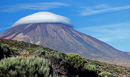
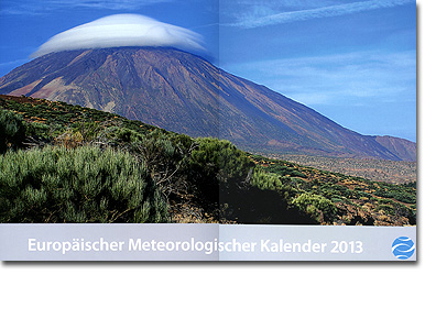
COPERTINA
Teide Hat, Tenerife, Canary
Islands, Spain
28 September 2011
Photographer: Iván Medina Delli
El Teide provides not only a geographic
reference for the inhabitants of the island of Tenerife, it has also
long been valued as an indicator of changes in the weather conditions
over the Canary Islands. When its 3,718 metres-high summit presents a 'hat',
the majestic Mount Teide is usually indicating the immediate arrival of
a front or atmospheric instability during the next 24 to 48 hours. The
hat is created when sunshine heats the mountain flanks and enables the
air to rise. If the air contains sufficient moisture, it condenses above
and forms a cloud. When there is virtually no wind, the cloud remains at
the mountain summit and covers it like a hat. |
|
|
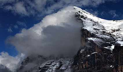
GENNAIO
Banner cloud over the north face of the Eiger
21 July 2011
Photographer: José Antonio Quirantes Calvo
The
picture shows a cloud that is typical for isolated mountains: a banner
cloud over the north face of the Eiger. The Glossary of Meteorology
published by the American Meteorological Society (AMS) defines the
banner cloud as follows: “A cloud plume often observed to extend
downwind from isolated, sharp, often pyramid-shaped mountain peaks, even
on otherwise cloud-free days. The Matterhorn and Mount Everest are two
notable peaks where banner clouds have been frequently observed. The
aerodynamics of the flow around the peak produces flow separation and
dynamically induced pressure reductions to the lee of the mountain peaks.
The magnitude of the leeside pressure deficits increases with height to
a maximum near the top of the peak, producing an upslope pressure
gradient and upslope flow along the lee slope of the mountain. When the
air near the base of the mountain is sufficiently moist, it ascends in
the upslope flow, condenses, and forms a triangular-shaped cloud, the
banner cloud, to the lee of the peak.” |
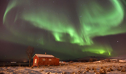
FEBBRAIO
Aurora Borealis, Tromsř, Norge
31 December 2011
Photographer: Hanneke Luijting
This image was taken on the last day of 2011, on a cold and clear night.
Even after four years in Tromsř, I never get bored of chasing the
beautiful aurora borealis. Also known as the northern lights, this is a
natural light display that occurs when streams of charged particles from
the sun’s solar wind collide with the earth’s atmosphere in the polar
regions. On this evening, I had been taking photos of the northern
lights reflected in the fjord, but as the lights got weaker I decided to
go home. On my way to the car, I suddenly spotted this photogenic cabin.
While I was setting up my tripod and taking some photos, the skies
suddenly went crazy - one of the brightest aurora I'd ever seen, dancing
all over the sky. I felt so lucky! It was an incredible moment, and I
was very happy to capture it together with the picturesque old cabin.
Who needs fireworks when the sky has its own light show? If it weren’t
for the cabin, I would have missed the show!
Hanneke Luijting |
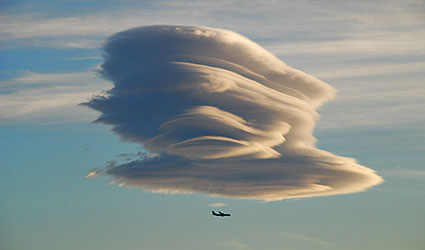
MARZO
Signs
in the sky,
Tenerife, Canary
Islands,
6 October 2011
Photographer: Iván Medina Delli
During this evening,
spectacular altocumulus lenticularis clouds formed above the coast on
the eastern side of Tenerife, on the leeside of the mountains. They are
illuminated by the evening sun and display numerous filigree-like cloud
parts. These clouds remained stationary for several hours, while
changing their shapes. Many residents within the area noticed what was
happening up in the sky, staring spellbound at the amazing clouds above.
The clouds continued to form astonishing shapes for some time, as we can
see in this photograph. The airplane in front of this spectacular cloud
gives this image a special touch.
Iván Medina Delli |
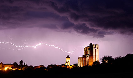
APRILE
Light touch, La Romieu, Collegiate Church Saint-Pierre,
Gascogny, southwest France
10 May 2010
Photographer: Pierre-Paul Feyte
Like a long arm, the
lightning appears to reach out and touch the two towers of the monastery
church from the 14th century and spectacularly illuminates them. This is
inter-cloud lightning, i.e. the electrical discharge occurs from cloud
to cloud. – “As the ice particles
within a cloud (called hydrometeors) grow and interact, they collide,
fracture and break apart. It is thought that the smaller particles tend
to acquire positive charge, while the larger particles acquire more
negative charge. These particles tend to separate under the influences
of updrafts and gravity until the upper portion of the cloud acquires a
net positive charge and the lower portion of the cloud becomes
negatively charged. This separation of charge produces enormous
electrical potential both within the cloud and between the cloud and
ground. This can amount to millions of volts, and eventually the
electrical resistance in the air breaks down and a flash begins.”
(From:
http://thunder.msfc.nasa.gov/primer/index.html) |
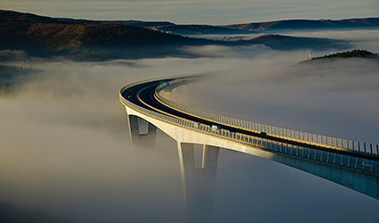
MAGGIO
Highway to heaven,
Crni Kal Viaduct, Slovenia,
17 January 2011
Photographer: Marko Korosec
The viaduct, which
is situated 20 kilometres east of the Slovenian coastal town of Koper,
spans the valley at a height of around 87 metres. In January 2011,
Slovenia experienced more than ten days of cloudless but nevertheless
mild high-pressure weather. As a result of nocturnal irradiation, the
air masses close to the ground cooled down and moisture condensed to
form widespread patches of fog, which in the valleys also did not
dissipate during the day. Although the motorway is illuminated by the
morning sun, it still appears to vanish into the fog – like a highway to
heaven. Further photos are available at
www.weather-photos.net. |
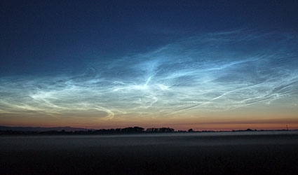
GIUGNO
Clouds at the edge of space,
Kilwinning, Scotland, UK,
3 July 2011, 01:15 UTC
Photographer: Bill Ward
Delicate, cirrus-like noctilucent clouds cover the northern sky. They
are illuminated by the sun that is situated far beyond the horizon,
which explains their appearance in summer during the midnight hours.
From the 2000 Meteorological Calendar: The clouds form at heights of
around 80 kilometres where very little water vapour exists. Therefore,
in order that the ice clouds can nevertheless form, the temperature has
to fall below -130°C and condensation nuclei must be available, e.g.
from volcanic eruptions. The respective mesopause layers are only cold
enough in summer to compensate for the warmth of the earth's surface and
the troposphere. This likewise explains the restriction southward (in
the northern hemisphere): the further the clouds travel towards the
equator, the further they move into warmer regions of the mesopause and
so the ice crystals dissolve. |
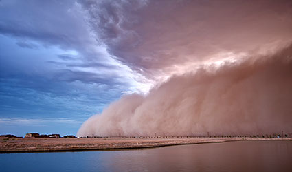
LUGLIO
Haboob near Phoenix, Arizona, USA
4 July 2011, evening
Photographer: Chris Voyles
This is an example of
one of many dust storms in the metropolitan area of Phoenix, AZ, USA on
4 and 5 July 2011. The photograph overleaf was taken near Maricopa,
about 50 kilometres south of Phoenix, in the evening of 4 July 2011.
This haboob produced little precipitation locally, but gusts of up to 65
mph (= 104 km/h) and intense dust uplift for about 1.5 hours. The
lifting of moist warm air by the approaching dust front leads to the
formation of a clearly visible shelf cloud.
Peter Knippertz
|
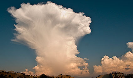
AGOSTO
Cumulonimbus capillatus, thunderstorm cloud, Tarxien,
Malta
3 October 2011
Photographer: Clinton Caruana
This cloud with a
‘cap’ developed above the western Mediterranean and Malta in a weakly
defined cold pocket aloft with a pressure of 500 hectopascal (= 5.6 km
altitude). In ombination with warm, moist air at the lower air levels,
which was fuelled by the warm Mediterranean Sea, this created
considerable atmospheric instability. This led to the formation of very
isolated clouds with extremely large vertical extents, such as this
cloud, which probably extended to more than 10 kilometres in height.
They were able to grow to such heights because no wind shear occurred (change
in the wind speed or direction with height).
|
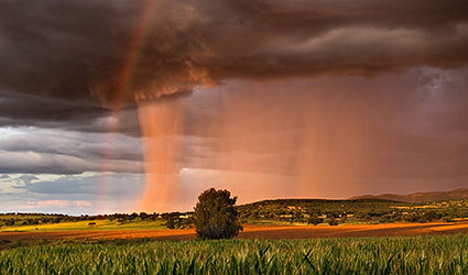
SETTEMBRE
The column
(Virga = precipitation trail),
Acedera, Badajoz,
Extremadura, Spain
24 April 2011
Photographer: Juan Pablo Cerro Bermejo
As the sun began to
set, a rain shower produced this wonderful view.
Illuminated by the warm light, the impressive column of rain developed
on the edge of a thunderstorm and is accompanied by a faint rainbow.
Such
precipitation trails develop in clouds with significant vertical extent
in which precipitation is initially produced in the form of snow or
graupel, and in summer often as hail. As it falls the precipitation then
melts in warmer air and arrives on the ground as pelting rain.
When
there is very dry air, for example, in steppe and desert regions, the
precipitation trails often do not reach the ground because the
precipitation already evaporates as it falls.
|
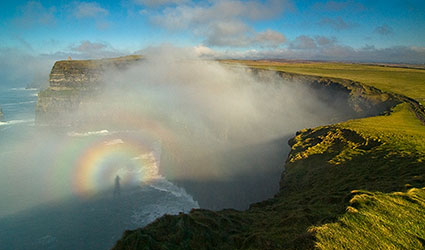
OTTOBRE
Glory (Brocken Spectre)
from the Cliffs of Moher, west coast of
Ireland
16 February 2011
Photographer: Sean Tomkins
A Glory, a Brocken
Spectre, is a rare optic phenomenon when a person standing on a higher
altitude with the sun directly behind him can see his own shadow cast
onto a cloud at a lower level. The shadow is often surrounded by rings
of coloured light – the glory. This phenomenon causes the circular
rainbow-like bands around the shadow by both diffraction and diffusion
of light at the small fog droplets. Historically there were many
sightings in the Harz mountains in Germany and its highest peak called
Brocken. This is the story behind this photo: one morning I found myself
on the Atlantic coast in dense fog. With no sign of it clearing, I
thought that at 214 metres high the Cliffs of Moher should be above the
fog. Finally out came my camera having found a good position. As I
walked closer to the edge my shadow was cast onto the fog. Suddenly a
‘rainbow’ started to appear around my shadow – the ‘glory’.
Sean Tomkins |
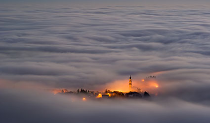
NOVEMBRE
The land of Fairy
Tales,
Conco, Italy
5 December 2011
Photographer:
Vittorio Poli
One December evening
I was coming down a mountain in the Asiago plateau (Province of Vicenza
in the Vento region of Italy), from an altitude of about 1000 metres to
the place where I live in the Italian Alps, when my attention was
suddenly drawn to a sea of fog that was slowly enveloping the
surrounding landscape. The small town of Conco, where I live, was
shrouded in fog like a floating island. I stood and watched the
spectacle in awe. Deeply moved by what I saw, I took this picture …perhaps
of the most beautiful I’ve ever taken.
Vittorio Poli |
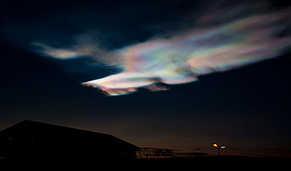
DICEMBRE
Mother of pearl
clouds,
turn of the year 2011/12, Hafjell near Lillehammer, Norway
Photographer: Sören Liebsch
The photos were taken shortly after sunset
looking from Hafjelltoppen towards the west. The temperature was -15°C
and it was almost windless. These clouds are also called polar
stratospheric clouds (PSCs). These spectacular, lustrous and colourfully
iridescent clouds form in winter at heights between 22 and 27 kilometres.
They form as soon as the air at these heights falls below the -80 °C
threshold. This happened on this day: the charts analysed by the
European Centre for Medium-Term Weather Forecasting showed a minimum
temperature of -88°C at heights of around 23 km above southern Sweden.
Such clouds were first described in 1870, several years before the
eruption of the Krakatoa Volcano in 1883, whose plume of ash and gases
is believed to have considerably cooled down the stratosphere. |
|