|
DESCRIZIONE (a cura dell'Editore)
|
12 belle fotografie
meteorologiche di grande formato, piů la copertina, ci accompagnano
mese per mese durante tutto il nuovo anno. Sul retro di ogni pagina
troviamo un ampio commento trilingue (inglese, francese, tedesco)
relativo all’argomento meteorologico rappresentato dalla fotografia
del mese. Il tema scelto per quest’anno č: “Sistemi di allerta in
meteorologia”.
Non solo un calendario, quindi, ma un vero e proprio libretto ricco di
informazioni, da conservare e collezionare. Un corposo lavoro curato
da un team europeo di specialisti, con la supervisione dell’
European
Meteorological Society.
|
|
LE
IMMAGINI DELL'EUROPEAN METEOROLOGICAL CALENDAR 2012 |
|
|
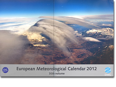
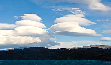
COPERTINA
Cloud vanes over the Pyrenees, 19 December 2010
Photographer: Jordi Martín García
This image was taken flying
over La Cerdanya Valley (Catalonia, Spain). Winter was approaching, a
cold front had passed and a strong airflow coming from the north caused
the first snowfall of the year in the Pyrenees. Because the intense air
stream flowed almost at right angles to the mountains, mountain wave
phenomena occurred that were accompanied by the characteristic
altocumulus lenticularis clouds. This photograph was taken at an
altitude of 30,000 feet (about 10,000 m). At this level there was only
slight turbulence, in contrast to the bumpy ride we had experienced
during our climb. |
|
|
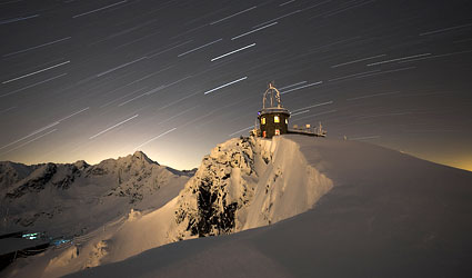
GENNAIO
Kasprowy Wierch Observatory, Tatra Mountains, Poland,
1,991 m (exposure 45 minutes)
Photographer: Witek Kaszkin
On 28 January 2011 the sky
was clear, the temperature around midnight was -9 °C and the snow had a
depth of 79 cm. “I set up my camera, which has a powerful battery, on a
tripod in the snow. I set a long time exposure of 45 minutes and went
back to work (in the observatory). In the morning I went to fetch the
camera and discovered that the camera had managed to take four pictures
before the battery ran out.” – Here are some meteorological values: mean
annual temperature 0.8 °C, absolute lowest temperature -30.2 °C in
January 1963, highest temperature +23 °C in July 1957, mean annual
precipitation 1,766.8 mm, maximum precipitation 2,396 mm in 1945,
maximum daily precipitation 232 mm on 30 June 1973, maximum snow depth
355 cm on 15 April 1995. (See also March page, Met. Calendar 2009) |
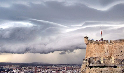
FEBBRAIO
'The gates of hell', Alicante, Spain, 11 May 2010
Photographer: Samuel Biener Camacho
Alicante, situated on Spain’s
Mediterranean coast, enjoys a healthy and warm climate with many hours
of sunshine throughout the year. This is because the weather on most
days is determined by either high-pressure areas or west winds, which
lose their humidity after blowing across the Iberian Peninsula and
arrive very dry. However in spring, and particularly in autumn, the
weather is not always so kind. If warm and humid Mediterranean air
coming from the east meets cold air at higher levels of the atmosphere
and/or if it collides at ground level with cold air coming from the
north, severe thunderstorms can occur. An example of such a thunderstorm
can be seen in the photograph, which was taken from the top of Mount
Benacantil. It produced 20 mm of rain and generated gusts exceeding 150
km/h. The author called this image 'the gates of hell'. |
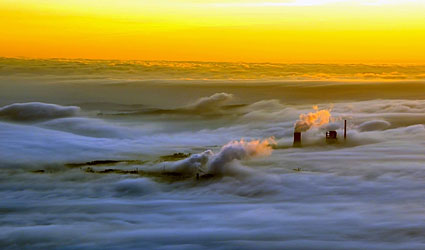
MARZO
Chimney plumes above low fog, 23 October 2010
Photographer: Jordi Martín García
We took off from Santiago de
Compostela (Galicia, Spain) and headed north, quickly reaching the area
of La Coruńa. On this day we were lucky with the weather conditions,
enabling us to enjoy this landscape. The chimneys and their plumes from
the thermal power plant at Meirama emerged from the sea of fog,
illuminated by the early morning light. This light produced warm hues,
which made up for the low temperatures at this time of the year. The
airports in the area, including at Santiago, Coruńa and Vigo, had to
operate throughout the morning with low visibility procedures. These are
in force when the Runway Visual Range is 400 m or less, and causes
delays to scheduled operations. |
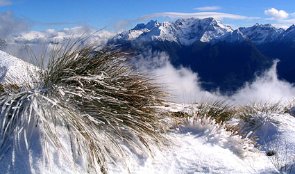
APRILE
Onset of winter in New Zealand’s Fjordland region, 8 April 2004
Photographer: Sebastian Dikty
The Kepler Track hiking
route affords a spectacular view of New Zealand’s mountainous Fjordland
region. The virgin snow and frost, combined with the mist rising from
the blue-coloured fjord below, looks almost out of a fairytale. The mist
has formed in the cold air that flows in above the relatively warm water
in the fjord. It is spreading up the slope of the mountain, carried by
the weak air movements. Cumulus clouds in the upper left part of the
picture and to the far right above the mountains are typical for the
vertically instable layers of cold air that are flowing in. The frozen
tuft of tussock grass in the foreground and the lenticular foehn clouds
above the mountains in the background instil the picture with a
considerable sense of depth, whereby the cold air ensures that it is
possible to see more than 50 km into the distance. |
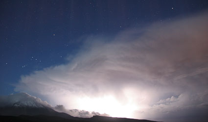
MAGGIO
Thunderstorm develops above Mount Teide, Canary Islands, 30 November
2010, 06:46 UTC (18-second exposure)
Photographer: Jürgen Rendtel
The Canary Islands can
sometimes experience very stormy weather during the autumn and winter.
Just a few hours before this photograph was taken, a storm occurred with
wind speeds that, according to the measurement equipment on the
neighbouring building, exceeded 200 km/h. The storm also produced heavy
rain that, as a result of the wind pressure, flowed under roof covers in
the most unbelievable directions and, for example, actually sprayed
upwards into the observatory dome, which is otherwise completely
rainproof. The storm then cleared up, only to be followed during the
early hours of the next morning by another thunderstorm front. This had
such a sharply defined front edge that the transition from the clear
starry sky to the thunderstorm was almost terrifying, whereby you can
also see the snow on Mount Teide. However, the wind did not blow quite
so severely as it had during the storm the night before. |
GIUGNO
Thunderstorm cloud over Majorca, Spain, 1 November 2010
Photographer: Miguel Angel Farińa de Jesús
On this day the atmosphere
was very instable. As a result, cumulonimbus clouds (thunderstorm clouds)
like the one shown in the picture developed all around the island. They
produced precipitation, with heavy rainfalls over localised areas that
were sometimes accompanied by hail. I took my rucksack with my camera
equipment and went to the cliffs on the western side of the island, in
the region of Calviŕ. I travelled as far as Punta da Cala Figuera
lighthouse, which offers an excellent view of the Bay of Palma. From
there I could see the impressive development and growth of this
magnificent cumulonimbus, which was situated across the bay on the
eastern side of the island. |
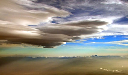
LUGLIO
Foehn clouds above Patagonia
Photographer: Sabine Bork
The photo was taken on 16
November 2010 on Lago Pehoe in Torres del Paine National Park, which is
located in the Chilean part of Patagonia. For Patagonian conditions the
day started with little wind and was already rather warm and muggy. It
then rained and within a short space of time the wind freshened up to
around 35 knots and the temperature dropped noticeably. To the rear of
the frontal system, lee waves then developed everywhere, and with them
wonderful examples of the associated foehn clouds that make the heart of
every glider pilot beat faster.
|
AGOSTO
Flight under turbulent clouds, 14 December 2006
Photographer: Jordi Martín García
Our flight took us to
Granada in the south of Spain. Near Sierra Nevada, large air currents
merged together. This resulted in mountain waves, which occur very
frequently in this area. In this case the presence of this
meteorological phenomenon is revealed by the altocumulus lenticularis
clouds, whereby there was only slight turbulence provided that one
remained at a lower flight altitude far enough away from the clouds.
However, considerable turbulence was evident at low altitudes near the
airport, and we experienced strong and gusty winds during the entire
approach and landing. |
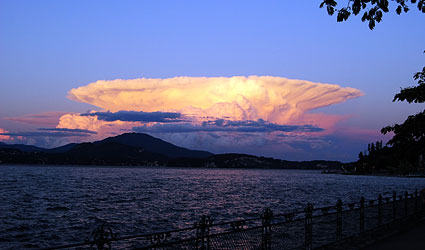
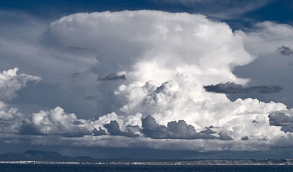
SETTEMBRE
A 'perfect' thunderstorm cloud, 3 August 2010, 20:52 CEST, Lago
Maggiore, Italy
Photographer: Karsten Bubner
The thunderstorm cloud (cumulonimbus),
which is illuminated by the setting sun, was photographed on the western
shore of Lago Maggiore looking towards the south. It has a
perfect-looking appearance, since the upper part of the cloud, the
frozen anvil, has spread out equally on all sides. This indicates that
there is little movement in atmosphere, in which the cloud extends up to
a height of 12 kilometres. The cloud developed during the course of the
afternoon without substantially changing its position. Although the
thunderstorm produced considerable precipitation in the mountains, the
view across the lake looks very peaceful, with the waves reflecting the
colour of the cloud that contrasts with the blue sky. |
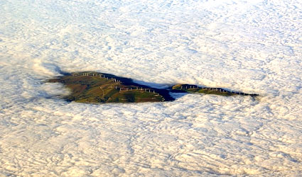
OTTOBRE
Wind farm emerging from low fog, 30 November 2010
Photographer: Jordi Martín García
Galicia is once again the
land of clouds and fog. In this Spanish region, large areas are
frequently covered by low clouds, especially in anticyclonic situations.
Here, wind turbines from a wind farm located in Serra Da Meira emerge
from this sea of clouds, as if they were located on islands in the
middle of the ocean. This photograph was taken on a flight from
Barcelona to Vigo, just as the plane started its final descent from
35,000 ft (11,500 m). |
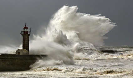
NOVEMBRE
Freak wave, Foz do Douro (mouth of the Douro), Porto, Portugal, 9
October 2010
Photographer: António Tedim
The roughly 15 metre-high
lighthouse on the jetty is hit by a wave whose spray reaches almost
twice the height of the tower. Several severe low-pressure areas had
already been rapidly moving across the Atlantic from Newfoundland to the
Bay of Biscay since 3 October. On route eastwards, their associated
storms generated a very high swell that was reinforced by the winds from
the individual low-pressure vortices. This spray is the result of the
very long swell waves which, just a few metres in height, were generated
by the wind sea and which crossed a large part of the North Atlantic. |
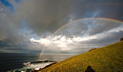
DICEMBRE
Double rainbow, Lekeitio, Biscay, 19 February 2010
Photographer: Xabier Gezuraga
The rain alternated with
sunshine, which caused an incomplete rainbow. While I was photographing
it, a cumulonimbus cloud approached and covered the sun, so that the
remains of the rainbow disappeared. The cumulonimbus produced a heavy
shower. A few minutes later, the sun began to peek out again from
underneath the cloud. When the rain finally arrived at the position
where I was standing, this beautiful double rainbow could be seen,
whereby my shadow can also be seen at the centre of the semicircular
arc. The second rainbow, which runs parallel to the brighter main
rainbow, can be seen best of all against the dark clouds behind it.
|
|